Earthquakes
-

Iceland Volcano: Continued Ground Uplift beneath Svartsengi -- Iceland Met Office
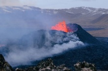
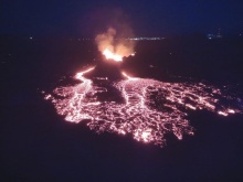
Photo taken on Dec. 19 at 15:00 and shows the three fountains, the most powerful being from two of them. At the front of the picture is the lava tongue that stretches to the west just north of ...
Read more... -
Iceland Volcano: Unabated Ground Uplift At Svartsengi -- Iceland Met Office
New hazard assessment map: Unchanged hazard assessment for Grindavík Information updated regularly here and on X (Formerly known as Twitter). Iceland Met Office Updated 22 December at 17:00 UTC As ...
Read more... -
Iceland Volcano: No Visible Eruptive Activity -- Iceland Met Office
Photo taken on Dec. 19 at 15:00 UTC and shows the three fountains, the most powerful being from two of them. At the front of the picture is the lava tongue that stretches to the west just north of ...
Read more... -
Iceland Volcano: The Eruption Is Focused On Five Vents -- Iceland Met Office
The eruptive fissure is about 4 km long, with the northern end just east of Stóra-Skógfell and the southern end just east of Sundhnúk. The distance from the southern end to the edge of Grindavík is ...
Read more... -
Iceland Volcano: An Eruption Has Started On The Reykjanes Peninsula -- Iceland Met Office
The eruptive fissure is about 4 km long, with the northern end just east of Stóra-Skógfell and the southern end just east of Sundhnúk. The distance from the southern end to the edge of Grindavík is ...
Read more... -
Iceland Volcano: Too Early To Say If Magma Accumulation Has Stopped At Svartsengi -- Iceland Met Office
A new hazard map to be released Dec. 20 Information updated regularly here and on X (Formerly known as Twitter). Iceland Met Office Updated 16 December at 14:00 UTC At this stage, it is too early to ...
Read more... -
Iceland Volcano: Svartsengi Continues To Inflate -- Iceland Met Office
Ongoing possibility of additional dikes forming or an eruption Information updated regularly here and on X (Formerly known as Twitter). Iceland Met Office Updated 13. December at 11:15 UTC The area ...
Read more... -
Iceland Volcano: More Magma Propagation Likely -- Iceland Met Office
In the last two days, approximately 200-300 earthquakes have been detected around the dike that formed November 10. So far today, around 100 earthquakes, the largest measuring M2.0, have been ...
Read more... -
Iceland Volcano: Seismic Activity Still Decreasing. The Unrest Phase Is Not Over -- Iceland Met Office
The risk assessment map from the Icelandic Meteorological Office was updated Nov. 22. The map is revised in line with the development of the functionality. The unrest phase is not over, difficult to ...
Read more... -
Iceland Volcano: Deformation And Seismicity Continue To Decrease While An Eruption Remains Possible -- Iceland Met Office
The risk assessment map from the Icelandic Meteorological Office was updated Nov. 22. The map is revised in line with the development of the functionality. If there would be an eruption, the most ...
Read more... -
Iceland Volcano: Unchanged Situation Based On The Latest Interpretation -- Iceland Met Office
COSMO-Skymed interferogram spanning 24-hours between 18−19 November at 06:41. The broad uplift signal visible in orange/red around Svartsengi is indicative of a deep inflation (>5 km) taking place. ...
Read more...


Page 5 of 9