Iceland Volcano: Activity At Sundhnúkur Is Ongoing -- Iceland Met Office
Uplift continues at a similar rate since the start of April.
Updated April 15 at 17:30 UTC
The volcanic eruption that began on March 16 is still ongoing.
Uplift continues at a similar rate since the start of April.
The hazard assessment is valid until April 16, unless the situation changes.
The risk of gas emissions remains significant. People in the area are reminded to monitor air quality.
The gas dispersion forecast can be found here
Just after noon yesterday, a small earthquake swarm began near Lágafell, just northwest of Grindavík. It concluded around half past three in the afternoon. The swarm consisted of approximately 90 earthquakes, with the most intense period of activity being 35 earthquakes between 1 and 2 pm. All earthquakes were under magnitude 1, and most were at depths of approximately 2-4 km. This small earthquake swarm likely resulted from stress changes in the Earth's crust due to ongoing land rise in Svartengi, as discussed in yesterday's news update.
Attached is a figure showing the location of the earthquakes on a map, and below that is a graph showing their depth. The panel in the top right displays earthquake magnitudes in the region from noon until evening yesterday. The panel in the middle right shows the cumulative number of earthquakes, while the bottom panel displays the number of earthquakes per hour. As the graph shows, several small earthquakes were recorded in the area yesterday afternoon, but there hasn't been any seismic activity in the region since midnight today.
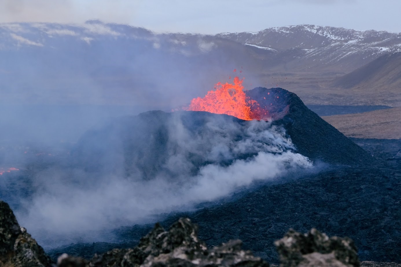 Photograph taken on Wednesday, April 10, showing the active vent as seen from Sundhnúkur. (Photograph: Jón Bjarni Friðriksson/Icelandic Meteorological Office). Click on the image to see it larger.
Updated April 14 at 18:00 UTC
The volcanic eruption that began on March 16 is still ongoing.
Uplift continues at a similar rate since the start of April.
The hazard assessment is valid until April 16, unless the situation changes.
The risk of gas emissions remains significant. People in the area are reminded to monitor air quality.
The gas dispersion forecast can be found here.
Several small earthquakes (below magnitude 1) have been detected northwest of Grindavík in the last few hours. (See figures below.) This seismic activity is focused near the dike that formed on November 10 and is likely related to the ground deformation in Svartsengi, which affects the region's pressure regime.
Today's seismic activity is comparable to the activity measured in this area in mid-March last year. Therefore, the seismic activity does not indicate any changes in the ongoing volcanic eruption, which has remained relatively stable over the weekend. The seismic activity northwest of Grindavík is also not indicative of magma moving beneath that area.
At the time of writing, the seismic activity northwest of Grindavík has slightly decreased. It is unlikely that large earthquakes will accompany this current activity.
Should magma deviate from its current route that surfaces at the Sundhnúkur crater row, opting instead for an alternate path, such as heading west towards Eldvörp or south of Þorbirnir, the precursor to a possible eruption in that area would involve very intense seismic activity and ground deformation that is clearly visible on instruments and satellite imagery. Currently, there are no such signs at this time.
The Icelandic Meteorological Office continues its 24-hour surveillance of the area to monitor the eruption site.
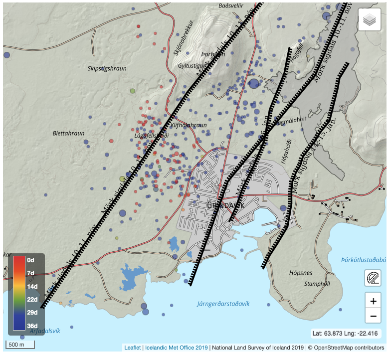 This figure displays seismic activity from March 9 until today, April 14. The black lines represent the outer boundaries of the grabens formed in connection with the significant dike intrusion on November 10, 2023, and the eruption on January 14 of this year. Most of the earthquakes today have been smaller than magnitude 1. Blue circles represent earthquakes that occurred from March 9 to 14, while red circles represent earthquakes that occurred today, April 14. The earthquakes are located on the western edge of the depression formed on November 10.
In the area northwest of Grindavík, there is a series of known faults with a north-south orientation that formed when the dike intrusion occurred on November 10. Therefore, today's earthquakes are also indicative of stress release along these faults due to the land uplift in Svartsengi.
Updated April 12 at 14:15 UTC
- The volcanic eruption that began on March 16 is still ongoing.
- Land rise continues at a similar rate since the start of April.
- The hazard assessment is valid until April 16, unless the situation changes.
- The risk of gas emissions remains significant. People in the area are reminded to monitor air quality.
- The gas dispersion forecast can be found here .
The eruption that started at the Sundhnúkur crater row on the evening of March 16 is still ongoing. One vent remains active, as it has been since April 5. Lava continues to flow southward from the vent but does not travel far, so the lava field continues to build up near the crater. There are no apparent signs of lava advancing towards the protective barriers north of Grindavík, Suðurstrandarvegur, or Melhólsnáma.
Land rise in Svartsengi continues at a similar rate, which increased at the beginning of April. This is a faster rate than that observed from the start of the eruption on March 16 until the end of March. This indicates that the majority of the magma flowing into the reservoir beneath Svartsengi is accumulating there, causing an increase in pressure and ground uplift. While the eruption continues, there remains an open connection between the magma accumulation area in Svartsengi and the Sundhnúkur crater row, and a portion of the magma continues to flow to the surface there. Minor changes in the lava field can be observed between days, but the overall rate has been steady since the beginning of April.
The hazard assessment remains unchanged and valid until 15:00 on April 16. See more details here.
There is still a risk of gas emissions from the volcano, which could cause pollution on the Reykjanes Peninsula. People in the area are advised to monitor air quality and familiarize themselves with symptoms of exposure to volcanic gas pollution.
- CreatedMonday, April 15, 2024
- Last modifiedThursday, April 18, 2024
