
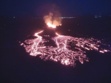
Iceland Volcano: Eruption Continues In Sundhnúkur Crater Row -- Iceland Met Office
Categories
Edited | All Content | Disasters | Earthquakes | Volcanos | Government | Science | Europe | Atlantic Ocean | News | News -- WNT Original
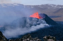
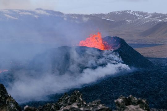 Volcano eruption at Sundhnúkur. Photo taken 10. April 2024 by Jón Bjarni Friðriksson/IMO
The lava field is becoming thicker close to the barrier East of Grindavík
Updated 23. April at 18:00 UTC
The eruption continues from the single vent formed since 5 April just East of Sundhnúkur.
Lava continues to extrude and propagate toward the south along open channels that are clearly visible from the cameras. The lava is also traveling longer distances from the crater through a network of closed tubes, which prevents the lava from cooling by direct contact with the atmosphere.
The sector of the lava field that has been propagating toward the South, -- and reached the protective barriers built East of Grindavík town -- has been thickening in the past few days, as shown in the images below. The images show the differences in the lava field profile between 18 and 23 April.
The image at the top is taken from the camera owned by the Icelandic Civil Protection located at the barrier East of Grindavík looking toward the part of the lava field that propagated toward Suðurstandavegur at the beginning of the eruption.
The image at the bottom is also from a camera owned by the Icelandic Civil Protection and it is located on top of Hagafell hill and is oriented to the South.
Estimates of the lava extrusion rate show values between 3-4 m3/s since the beginning of April. The last measurements were made on 15 April, so we are now waiting for new acquisitions which will be available next week, to shed light on the level of the current activity and to understand if there have been any significant changes.
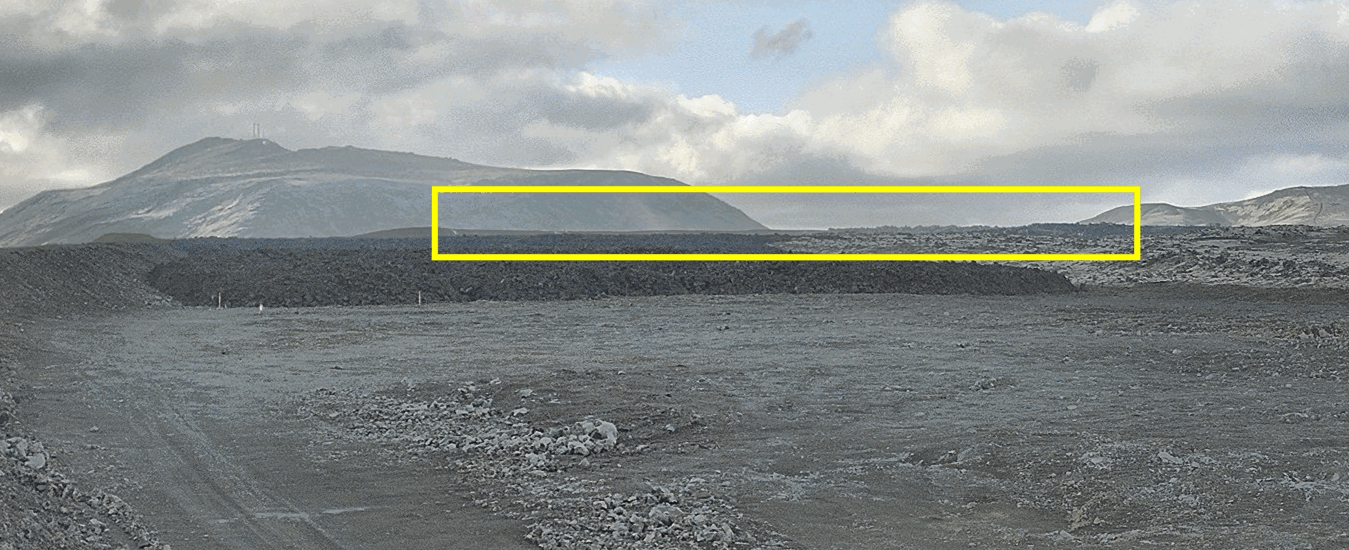 Image from the camera, owned by the Icelandic Civil Protection, located at the protective barrier East of Grindavík town. The camera is oriented to follow the lava tongue which propagated towards Suðurstrandavegur at the beginning of the eruption. The yellow box indicates where the lava field has been thickening the most over the past few days.
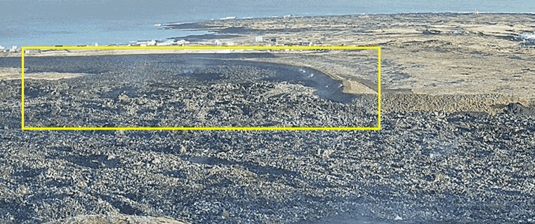 Image from a camera, owned by the Icelandic Civil Protection, located on top of Hagafell Hill and is oriented toward the south. The yellow box indicates where the lava field close to the protective barrier has been thickening the most over the past few days.
The ground uplift measured around the Svartsengi region continues, indicating that magma accumulates at depth at a stable rate and the total inflow to the reservoir is greater than the outflow feeding the eruption. By using analytical models, constrained by both GNSS and InSAR data, it is assessed that between 7-8 million m3 of magma has been recharged to the Svartsengi reservoir since the eruption commenced on 16 March. In previous events, magma started propagating as dike intrusions from the reservoir at 4-5 km depth towards the surface when a threshold of about 8-13 million m3 of recharged magma was reached.
As long as the magma continues accumulating in the Svartsengi reservoir, the likelihood for a significant escalation in the eruptive activity in Sundhnúk crater row increases.
- New eruptive fissures may open in the area between Stóra-Skógfells and Hagafells and/or the current eruptive vent may enlarge because of a sudden increase in magma flow rate, which might reach levels comparable to those observed at the beginning of the past four eruptions which occurred in the area. If this happens, very short precursors, if any, are expected.
- It is also possible that if more magma starts propagating from the Svartsengi reservoir to the Sundhnúks crater row, this could happen gradually until a balance between the inflow rate at depth and the extrusion rate at the surface is reached.
There is also the possibility that a new dike intrusion will result in the opening of additional eruptive fissures in areas other than between Stóra-Skógfells and Hagafells. This scenario is, however, considered less likely than those previously stated, and if this happens, longer and more intense precursors are expected to occur.
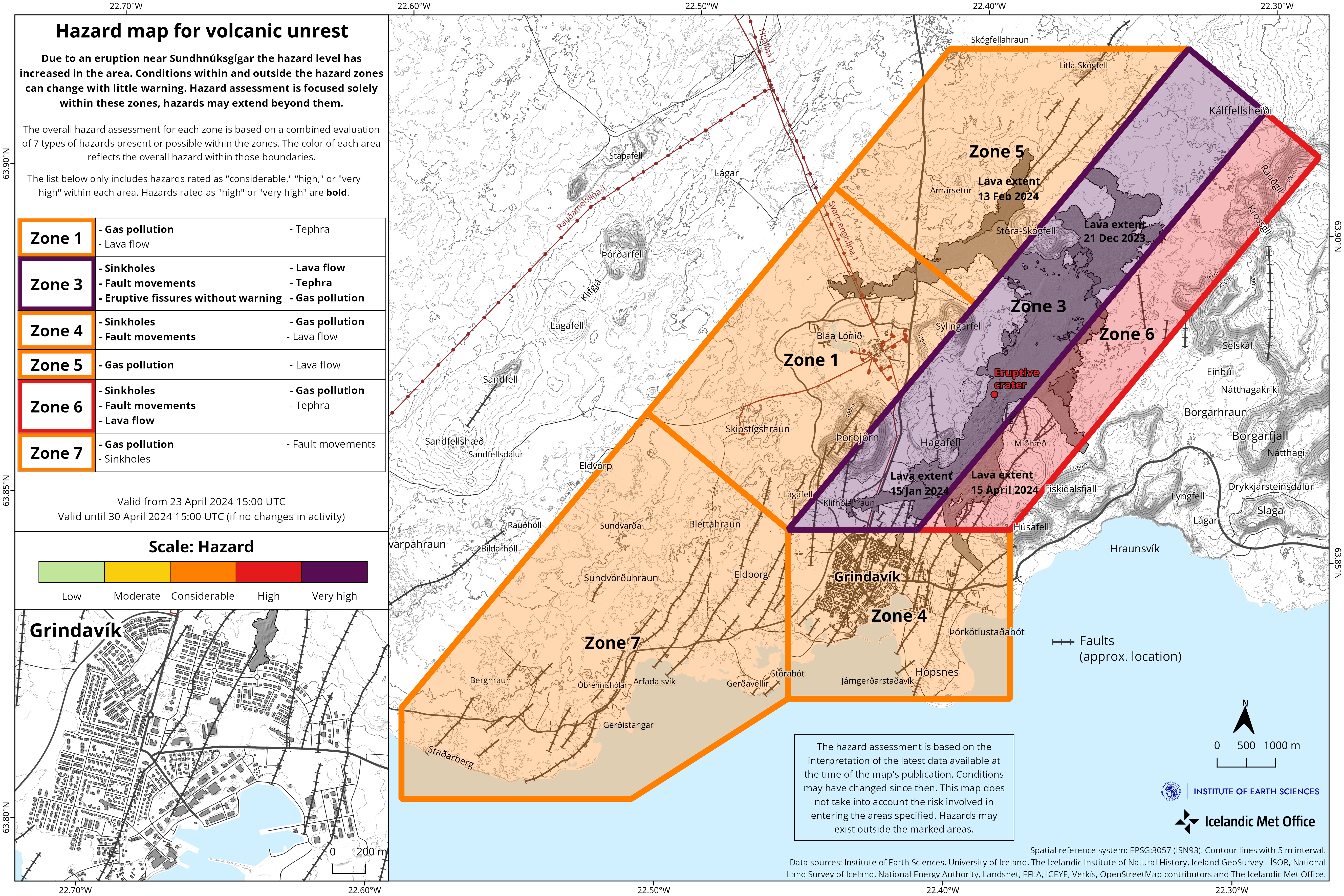
Updated hazard map
During the scientific meeting this morning, the hazard assessment for the ongoing activity was reviewed. The likelihood of opening of eruptive fissures within Zone 1 (Svartsengi), Zone 4 (Grindavík) and Zone 7 has been reduced from being considerable to low.
On Friday last week, due to the continued inflation of the Svartsengi reservoir, and the high uncertainty regarding this new situation and possible outcomes, the decision was made to temporarily increase the likelihood for eruptive openings within these areas. However, following the meeting today, it has been agreed that there is currently no evidence for an increased probability of eruptive openings in these areas.
 Click image to enlarge.
While the eruption continues, it is assessed that if increased magma flow occurs, the magma will most likely follow the open pathways feeding the current eruption and/or new eruptive fissures may form nearby. For this reason, the likelihood of eruptive openings without warning is still assessed to be very high within Zone 3 (Sundhnúks crater row), which remains unchanged.
- CreatedTuesday, April 23, 2024
- Last modifiedSaturday, April 27, 2024
World Desk Activities

cpj.org/resources-for-journalists-covering-protest…

cpj.org/2020/09/guide-to-legal-rights-in-the-u-s/

pressfreedomtracker.us/submit-incident/

drive.google.com/file/d/17XyVCVOTq59bvTEG_RZAQMgrF…

www.icfj.org/news/new-icfj-knight-fellows-work-sup…

U.S.Justice Department: "Radical Right vs. Radical Left: Terrorist Theory and Threat"
www.ojp.gov/ncjrs/virtual-library/abstracts/radica….
ijnet.org/en/story/tips-building-networks-reach-au…

trustingnews.org/how-trustworthy-is-your-newsroom-…

Latest Stories


Electronic Frontier Foundation
The Intercept
- In No Labels Call, Josh Gottheimer, Mike Lawler, and University Trustees Agree: FBI Should Investigate Campus Protests May 04, 2024
- Let’s Check In on AIPAC’s Assault on the Squad May 04, 2024
- AIPAC Is Secretly Intervening in Portland’s Congressional Race to Take Down Susheela Jayapal, Sources Say May 03, 2024
- NYC Mayor Smeared a Grandmother as an “Outside Agitator” to Justify NYPD Assault on Columbia May 03, 2024
VTDigger
- Plan for home-based cannabis business in Rutland leads to fight among neighbors May 05, 2024
- Young Writers Project: ‘Let the light in’ May 05, 2024
- Then Again: The minister who sided with John Brown and the abolitionist cause May 05, 2024
- David Moats: Searching for solutions and avoiding demagogues May 05, 2024
