
Iceland Volcano: Unabated Ground Uplift At Svartsengi -- Iceland Met Office
Categories
Edited | Front Page Stories | All Content | Disasters | Environment | Earthquakes | Volcanos | Science | North America | Europe | Atlantic Ocean | News | News -- WNT Selected
New hazard assessment map: Unchanged hazard assessment for Grindavík
Information updated regularly here and on X (Formerly known as Twitter).
Updated 22 December at 17:00 UTC
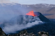
As announced yesterday, the fissure eruption at Sundhnúksgígar has ended. This indicates a temporary cessation of eruptive activity. In the last 24 hours, nearly 90 earthquakes were recorded in the Grindavík, Sundhnúksgígar, and Svartsengi regions. The largest earthquake was M1.6 west of Hagafell, just after 16:00 UTC yesterday (21 December). Overall, seismicity levels are low but variable on a daily basis.
According to GPS and satellite-based measurements, ground uplift in the Svartsengi region was apparent immediately after the eruption began on the evening of 18 December. Initial measurements show that the rate of uplift is greater than before the eruption occurred. This signifies that magma accumulation continues unabated beneath Svartsengi. This development will likely lead to another dike intrusion and, ultimately, a volcanic eruption. In the event of an eruption, the most likely source region is between Stóra-Skógfell and Hagafell.
Continuous GPS measurements show that the rate of daily ground uplift at Svartsengi between 10 November, when the magmatic intrusion formed, and 18 December progressively declined. This process is likely to repeat itself, meaning that the next dike intrusion could begin with little warning when the uplift rate decreases again. Therefore, the likelihood of an eruption increases day-by-day.
Following confirmation of the end of the 18 December eruption, the Icelandic Meteorological Office has issued a new hazard assessment. The hazard map comes into effect at 16:00 UTC today (22 December), and it remains valid until 18:00 UTC on 29 December. The main changes affect zones 2 and 3, where hazard levels have reduced from very high (purple) to high (red). The hazard assessment for all other zones is unchanged. Notably, the assessment for Grindavík is unchanged from the previous map, and the hazard level remains considerable. We emphasise that conditions can change rapidly, and that weather conditions can significantly affect the sensitivity of our monitoring networks. Under such conditions, the warning time could shorten considerably.
The weather forecast for Grindavík on 23 December calls for northeast wind 10-15 m/s, intermittent snowfall, and possibly drifting snow. Temperatures will be low, between 3 to 5°C. On 24 December, winds from the north 13-18 m/s with occasional snow showers, but 10-15 m/s in the afternoon with decreasing snow showers. Intermittent drifting snow can be expected. Temperatures will be from 0 to 2°C
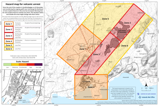 The latest hazard assessment map, published on 22 Dec., 16:00 UTC. It is important to note that new hazards could arise with little warning within the specified areas. Additionally, the assessment applies only to the specified areas, whereas hazards could extend or occur beyond the identified zones.
(more)
- CreatedFriday, December 22, 2023
- Last modifiedFriday, December 22, 2023
SUBSCRIBE
Sign up for our weekly newsletter and World News Trust project updates.

World Desk Activities

cpj.org/resources-for-journalists-covering-protest…

cpj.org/2020/09/guide-to-legal-rights-in-the-u-s/

pressfreedomtracker.us/submit-incident/

drive.google.com/file/d/17XyVCVOTq59bvTEG_RZAQMgrF…

www.icfj.org/news/new-icfj-knight-fellows-work-sup…

U.S.Justice Department: "Radical Right vs. Radical Left: Terrorist Theory and Threat"
www.ojp.gov/ncjrs/virtual-library/abstracts/radica….
ijnet.org/en/story/tips-building-networks-reach-au…

trustingnews.org/how-trustworthy-is-your-newsroom-…

Latest Stories


Electronic Frontier Foundation
- EFF to Court: Electronic Ankle Monitoring Is Bad. Sharing That Data Is Even Worse. May 17, 2024
- EFF Urges Ninth Circuit to Hold Montana’s TikTok Ban Unconstitutional May 17, 2024
- Fair Use Still Protects Histories and Documentaries—Even Tiger King May 15, 2024
- The Cybertiger Strikes Again! EFF's 8th Annual Tech Trivia Night May 15, 2024
The Intercept
- The State Department Says Israel Isn’t Blocking Aid. Videos Show the Opposite. May 18, 2024
- Medical Workers Evacuated From Gaza, but 3 Americans Refuse to Leave May 17, 2024
- An Israeli Company Is Hawking Its Self-Launching Drone System to U.S. Police Departments May 17, 2024
- The Consumer Finance Protection Bureau Is Constitutional, After All May 16, 2024
